During the month of April 1997 french scientists of the S.V.E. and University of Savoie, accompanied by mountaineers visited the Beerenberg volcano on Jan Mayen Island. This first preliminary scientific expedition was carried out in cooperation with norwegian university of Bergen to improve the monitoring system. Main purpose of this mission : find a suitable site 1400-1800 m altitude on the side of the Beerenberg to implement a monitoring autonomous station ( various geophysical sensors).
The team climbed the volcano on April 6 in the morning - Only weak fumarolic activity was visible in the inner low part of the North-East crater wall - White steam rose few meters above this small active area. Beerenberg, is the northernmost active subaerial volcano in the world.
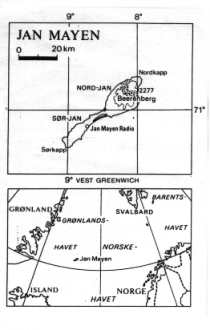
Jan Mayen is a small isolated Arctic island located on or very near the junction of the southern end of Mohns ridge and the central part of the Jan Mayen fracture zone. As such, it is the northernmost volcanic island on what is called the mid-Atlantic ridge and the northernmost active volcano in the world. The island lies rather isolated in the norwegian Sea between Iceland and Spitsbergen. The distance to Iceland is 600 km, to Greeland 500 km and to the Norway 1000 km. The island is 54 km long and the width varies between 2.5. and 16 km. The total area is 380 square km. The Northern half part of the island is dominated by Mt Beerenberg, a major central volcano, which is about 25 km in diamter at sea level and is capped by a nearly symmetrical summit lava cone reaching an elevation of 2277 m above sea level. The volcano is largely covered by an ice-cap sending glacier down to the sea level. At the top of Beerenberg volcano is a major crater, Sentralkrateret, about 1 km in diameter, open towards the West and feeding the largest glacier, Weyprechtbreen. The south-western part of the island is approximately 6 km wide and rise up to 600-700 m. This part of the island is a mountainous ridge built mostly of lavas, submarine hyaloclastites ans scorias craters. The island is built entirely of volcanic rocks younger than 0.7 m.y. The productivity of the volcanism is low. Around 100 years, on average elapse between eruptions and the average eruption amounts to about 0.07 km3 of magma (Imsland, 1978). Ankaramites and mg-rich basalts are most prominent on North-Jan Mayen while more evolved basats characterize South-Jan Mayen. Reports of eruptions in Mt. Beerenberg in previous time are very few, the only registered are in 1732 and 1818. The reason is probably the island's isolated location away from all normal sea route. Moreaver, the island is so often shrouded in low cloud and fog and has been so rarely inhabited in historic time that reports of volcanic activity are seldom, and even those reports were generally discounted by several authors writing prior to the 1970 eruption. In september 1970, the eruption of Mt. Beerenberg happend and this came as a surprise to everyone. From four craters on the eastern slope of the volcano lava poured out for more than four weeks. During this eruption more than 500 million cubic meters of lava poured into the sea and formed about 3.5 square km of new land.. On Sunday, January 6, 1985, a new eruption started on Jan Mayen island. The eruption took place on the NE flank of Beerenberg volcano, at the extreme North-East corner of the island. This last eruptive activity lasted only 35-40 hours and discharged from a volcanic fissure about 7 million m3 of magma. Historic data suggest a minimum eruption frequency of about 150 * 75 years. This, together with the fact that historic activity has been characterized by fissure eruptions only on the flanks of Beerenberg, suggest that future activity will be sufficiently far from the norwegian meteorological-Loran navigation system in space and time that the volcanic hazards are relatively low to personel stationed on the island but the studies about Jan Mayen island and the monitoring of this northernmost active volcano in the world is very interesting for a better understanding of the local tectonic and the eruptive processes of the Beerenberg volcano.
Informations: Henry Gaudru - S.V.E. CP.1 - 1211 Geneva 17- Switzerland - Michel Halbwachs, University of Savoie, France - Jens Havskov, Bergen University, Norway
Further details on Jan Mayen Island ( map and photos) webcam
 |
|
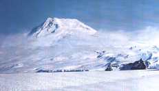
Beerenberg volcano - H.Gaudru - Copyright 1997
|
 |
|
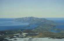
South
part of the Jan Mayen island- Copy- V.Teigen
|