MISSION ECUADOR - SVE - October - November 1999
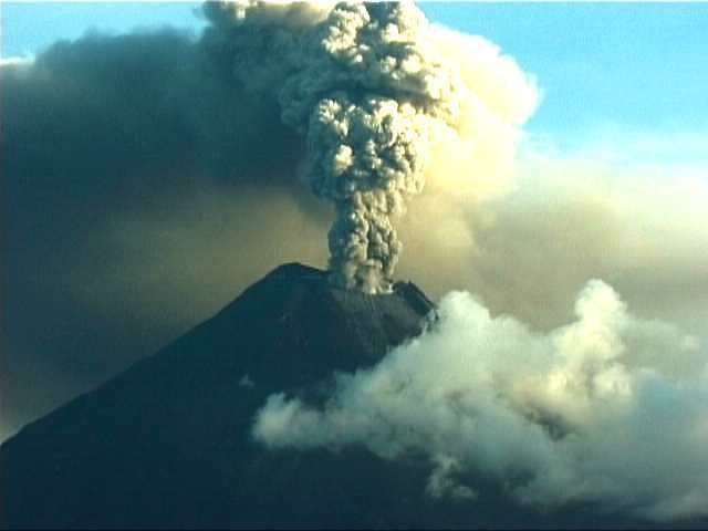 |
volcan Tungurahua depuis le Nord ( H.Gaudru - SVE -copyright)
VOLCAN TUNGURAHUA - Ecuador
Within the framework of the IAVCEI-IDNDR programme on mitigation of the volcanic disasters, a SVE scientific team visited Tungurahua volcano between end October and early November to observe eruptive activity and evaluate potential hazard in case of increasing eruption. Tungurahua is a large strato- volcano located on the eastern part of the cordillera Ecuadorian Andes, 120 km South of Quito and 33 km Southeast of the town of Ambato. This 5023 m-high volcano is one of the most active volcanoes in Ecuador. Over the last century, four eruptions occured : 1641, 1773, 1886 and 1916-1918. The 1886 and 1916-1918 eruption were characterized by emission of numerous pyroclastics flows which descended the flanks of the volcano. Lahars were also produced during the 1773, 1886 and 1916-1918 eruptions. The town of Banos narrowly escaped disaster in 1773, when a large debris flow in the Vazcun valley barely spilled over the city. From the study of historic and prehistoric activiy it is clear that pyroclatic flows and lahars triggered by pyroclastic flows/surge activity represent the principal hazard for the population living around the volcano. Preliminary information indicated that either August or September, a Phreatic eruptives actvity occured, with columns rising at least 1000m over the volcano. This activity occured after several months of increase in seismicity and fumarolic activity ( since Dec.1998 - Jan 1999). In May a dramatic increase in seismic activity begins. Tremor, apparently, was noted as well. In July, the volcano was emitting 2,000 metric tons of sulfur/day. First new reports of increased fumarolic activity were received. During the first week of August, a small but prominent gas cloud over the volcano becomes established. At the late August there were only four active summit fumaroles. On September, 6, there are 40 active fumaroles in and around the summit crater. New summit fissuring evident too. During early September, the sulfurour gas plume is typically rising to at least 1km above the summit. On September, 15, more than 50 phreatic events were recorded and the 17 October 1999 bulletin for Ecuador's Tungurahua showed the alert level has been raised to ORANGE. Volcanic tremor was so strong as to mask other seismic signals. Incandescent tephra again has fallen on the W flank. A continuous stream of gas and ash rose from the summit crater, which has become enlargened on a N-S axis (?). Moderate to high levels of SO2 emission was also continuing through October. Over the following days ashfalls occured on surrouding villages, and by safety the 20.000 residents of the town of Banos, located at the North flank of the volcano, and Ocatalo at the West flank were evacuated During our visit between end october and early november, the eruptive activity was characterized by moderate to strong explosions from the summit crater, triggering large volcanic plumes raising to several km high above the volcano. A crater overfly on November 1th showed the emplacement of the small lava dome ( 300 m) within the summit crater. Eruptive cinders column are maily dispersed by the prevailing winds toward West and Southwest and many ashfalls occured on the towns of Quero, Mocha, Penipe, Guano and sometimes on the city of Riobamba causing breathing convenients for the populations living in these areas. The road between Banos and Riobamba ( disrupted by lahars since several weeks) is covered with a cinders layer ( thickness 2-3 mm)
Evolution in the future - Hazards assessment
From the studies of historic and prehistoric activities, eruption scales probability expected are : VEI 1 ou 2 = 30% VEI 3 = 67% VEI 4 = 3% Major hazards for the population are pyroclastic flows and lahars triggered by pyroclastic flow/surge activity. Based upon the eruption frequency of the last millenium the emission of pyroclastic flows and lahars such as occured in 1886 and 1916-1918 are likely. In this case, Banos and several villages located on the western and northern flanks would be directly threatened. Others hazards as a sector collapse and associated debris avalanche can be expected. Although these types of events are rare, they have occured at least twice at the Tungurahua in the geologic past ( most recent event happened only 3000 years ago) ; The conditions of the present cone ( 3000 m relief and 30° slopes) could be favor a future collapse. If it were to happen, an avalanche of 1-3 km3 in volume could be generated and would have a catastrophic consequence. Lahars associated with collapse events by the remobilization of water-satured parts of the avalanche deposits or by the incorporation of water or snow could be occurs. Following the 3000-year old avalanche event, a 14 km long section of the Chambo river valley was blocked by the avalanche debris and associated lahar deposits, forming a natural dam and a 10-km-long lake. Following an avalanche event, lahars certainly represents the greatest hazards and this hazard remains high long after the eruption, especially when a large drainages are blocked and lakes are formed ( some of the largest lahars resulted from such lake breakouts. Tungurahua's setting invites such a possibility, even if the next collapse is of small volume (< 1 km3), the resulting debris avalanche would likely refill the narrow Chambo valley, damning it, which would probably generate another lake-breakout debris flow of significant proportions. Due to the relatively high viscosity of the typical Tungurahua magma, lava flows do not attain great velocities and thus do not represent an important hazard for populations living at the foot of the volcano. General conclusion : the more frequent eruptive episodes of each century characterized by pyroclastic flows, lavas, lahars, as well as tephra falls, directly threaten more than 25.000 people and the Agoyan hydroelectric dam located at the foot of the volcano. The four weeks evacuation of the town of Banos and surrounding areas which still continues will led inevitable hardship and in some case frustration among the population. In response to this, local authority with scientists cooperation must improve again the quality of information for the population concerning the risks and discouraging individuals or families who will run these risks from returning to their homes and activities in the unsafe area .
Geneva, November 15, 1999
Henry Gaudru ( International Commission on Mitigation of the Volcanic Disasters- IAVCEI-IDNDR) SVE, C.P.1 - 1211 Geneva 17 - Switzerland, Fax : 41.22.759.21.05 - Email : HGaudru@sveurop.org Jacques-Marie Bardintzeff, University Paris-Sud Orsay, France, Email : bardizef@geol.u-psud.fr
Reference : Minard Hall and Al., structure, Tungurahua eruptive history and hazards, JVGR, 1,1999 Risk Maps : IGEPN and IRD Quito - M.L. Hall, C.Robin, B.Beate, P.Mothes, M. Monzier